
Snow drought update
Plus, SnowSlang: J is for "jökulhlaup"


A lousy snow season in the Southwest went from bad to worse in April as warm temperatures and dry weather led to an accelerated melt-out. Other parts of the West also saw their snowpack shrink rapidly last month, but a stormy start to May offered a bit of relief.
Most ski areas were already shuttered for the season, but a few high-elevation resorts remained open and were able to offer some powdery turns. The May 7 photo below, from Arapahoe Basin’s Instagram page, made me pine for living in Denver, when I’d occasionally enjoy some sick powder days in May (e.g., this 2013 video).
As I noted in a recent post, April 1 is a key milestone for gauging the West’s snowpack, but the weather in ensuing weeks is a wildcard that can significantly shape the runoff season. This year, some basins in the West quickly switched from above-normal conditions to deficits due to the warm, dry weather.
“Rapid melt out occurred across Utah, Colorado, and New Mexico, pushing some basins from above-average snowpack to snow drought conditions in under a month, with snow disappearing 1-4 weeks early,” according to a May 1 snow drought update from the National Integrated Drought Information System. “Washington and Utah declared drought emergencies due to low snowpack, below-normal streamflow forecasts, and long-term drought impacts.”
The runoff forecast for the Colorado River, source of drinking water for some 40 million people, tumbled in April, with a May 1 federal report projecting that inflows to Lake Powell will only be 55%, down from 67% in the April 1 forecast, as shown in the chart below.

Here in southern Colorado, the season’s meager snowpack didn’t last long, as shown in the graphic below from the Colorado Climate Center, which highlights two other years—2002 and 2018—that featured major wildfires in this neck of the woods.

All that said, we enjoyed a lovely wet stretch here in the Southwest in early May, courtesy of a weather phenomenon known as an omega block, which caused several feet of snow to fall in parts of the high country. The graphic below shows the deviation from normal precipitation between May 1 and May 8.
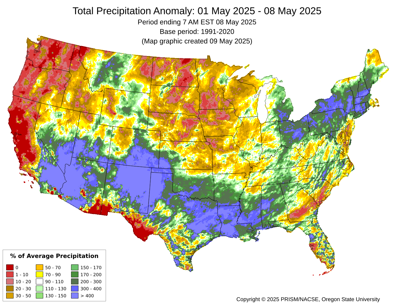
At the snow.news headquarters near Durango, we received a healthy 1.37” of rain, plus some snowflakes, graupel, and pea-sized hail. The wet start to May was welcome, but it only took a heartbeat for things to dry out again, and runoff levels in local rivers remain well below normal.
SnowSlang: J is for "jökulhlaup"
Last fall, I embarked upon a project to explain snow-related lingo by going through the alphabet and picking one word or phrase per letter to delve into. We’re now up to “J,” which means the first one-third is complete, so I thought it was time to look back on where we’ve been:
With the arrival of “J” and the approach of “K,” we’re now in a part of the alphabet that presents some more challenging letters for the enterprise. Only about 1 in 100 words in English begin with “J,” and it’s only slightly more common to find words starting with “K.”
The situation will grow more dire as I approach the end of the alphabet. According to a “relative rarity ranking” from ChatGPT (based on sources like the Oxford English Dictionary and Scrabble lexicon), here’s the bottom of the list when it comes to the beginnings of English words:
K: ~1.6%, mostly Germanic or Norse origin.
V: ~1.3%, almost entirely Latin/French loanwords.
J: ~1.0%, no presence in Old English; mostly Latin/French.
Y: ~0.9%, rare as initial letter; more common as vowel.
Q: ~0.7%, requires “u”; mostly Latin and French.
Z: ~0.3%, rare and almost always borrowed.
X: ~0.02%, rarest; nearly all Greek origin.
Without further ado, my choice for “J” is jökulhlaup, a type of flood emanating from glaciers that’s pronounced “yo-KOOL-lahp.” The word is Icelandic in origin and means “glacial run” in its native tongue.
Initially, the term referred to floods in Iceland that were triggered by geothermal heating or a volcanic eruption, but it’s now sometimes used more broadly to refer to any big release of water from a glacial lake.
“Glacial outburst floods or ‘jökulhlaups’ are a key part of deglaciation of both alpine mountains and of ice sheet margins,” according to a review in Geology Today. “They produce widespread and intense landscape change through erosion and deposition and are a hazard to populations and infrastructure.”
The paper concludes that “with increased intense rainfall events and with increased glacier melt due to climate change it is likely that outburst floods—including jökulhlaups—will increase in frequency and also in magnitude in the near future.”
The term “glacial lake outburst flood” (GLOF) is what you’ll see more often in the scientific literature. A 2023 study in Nature Communications concluded that GLOFs threaten 15 million people around the globe, with more than half of those at risk living in four countries: India, Pakistan, Peru, and China. A 2024 study in Nature Reviews Earth & Environment put the number at more than 10 million, projected a tripling of the hazard in high-mountain Asia by 2100, and included the instructive graphic below illustrating triggers/impacts.

“Jökulhlaups may occur with a somewhat regular periodicity, but others drain without warning,” according to the National Park Service, which also notes:
In order for a jökulhlaup to occur, the lake water levels must reach a critical point such that the lake:
Causes its ice dam to float
Overtops its dam, causing rapid incision into the sediment, rock, or ice that contains it
Carves large meltwater channels beneath the glacier ice that allow for rapid drainage
")
“Avalanches, rockfalls and slope failures can also trigger glacial lake outburst floods,” according to a recent piece in The Conversation. “These are growing more common as frozen ground known as permafrost thaws, robbing mountain landscapes of the cryospheric glue that formerly held them together. These slides can create massive waves when they plummet into a lake. The waves can then rupture the ice dam or moraine, unleashing a flood of water, sediment and debris.”
One type of jökulhlaup is a monster-sized megaflood, in which the dissolution of a glacial dam leads to the drainage of a ginormous lake, such as those that existed in North America toward the end of the last ice age.
The Missoula Floods, which swept across the Pacific Northwest around 15,000 years ago, are one of the best-known examples. Glacial Lake Missoula extended for around 200 miles and “contained more water than Lake Erie and Lake Ontario combined,” according to the U.S. Geological Survey. “When the highest of these ice dams failed, lake water burst through, shooting out at a rate 10 times the combined flow of all the rivers of the world.”
