Silly season: predicting the winter snowpack in summer
Plus new research on the Colorado River, and a crazy storm leaves me wondering whether hail is part of the cryosphere
On a camping trip last weekend near Telluride, I noticed the first leaves starting to change on the high-elevation willows and aspen. It’s still early September, but the nights are getting crisp, and it feels like fall is around the corner, so predictions about this winter’s snowfall are starting to drop.
Arapahoe Basin and Loveland, two Front Range ski areas that I miss from my days in Denver, have already recorded their first frostings:
Late summer is what politicos and journalists used to call the “silly season,” when a slow news cycle and lots of vacationing politicians led to the publication of more frivolous, less rigorous stories.
I’m not sure if there’s still a silly season in 2024, with year-round, 24/7 coverage of an explosive world that feels like it’s careening out of control, but I do think it’s silly to try to predict winter snowfall while it’s still summer!
As I argued in a post last year, many preseason forecasts are a joke, and you should take ‘em with a chunk of road salt. Publications like the Old Farmer’s Almanac, not to be confused with the Farmers’ Almanac, rely on “secret” formulas and are about as scientific and verifiable as astrological forecasts. To wit, check out the predictions below, which magically align with the state boundaries year after year. 🤔

I’d love to head down to Four Corners Monument to ground truth this and see if I can experience the three different weather regimes in various parts of my body by sprawling across the intersection of Utah, Colorado, Arizona, and New Mexico.
La Niña on the way?
Examining the forecast for El Niño and La Niña, formally known as the El Niño-Southern Oscillation (ENSO), hints at what may be ahead. This phenomenon has global impacts and tilts the precipitation odds in some places, but here in Colorado, it’s not very helpful for predicting snowfall.
The odds favor La Niña conditions developing this winter, with the latest forecast from NOAA projecting a 74% chance during the November to January period. La Niña is associated with wetter conditions in the Pacific Northwest and drier weather across the southern tier states like Arizona and New Mexico, but it’s certainly no guarantee.
As shown by the graphic below, the odds of “neutral” conditions are actually slightly higher than the probability of La Niña by the February to April period, and there’s a less than 30% chance La Niña will still be around by the March to May timeframe.

I also consulted NOAA’s Climate Prediction Center, which publishes long-range outlooks for precipitation and temperature, though they’re painted with a broad brush, and the further out you go, the less skillful the prediction.
Below are some maps showing expected precipitation and temperature in a series of three-month periods, beginning with October-December in the upper left, and ending with March-May in the lower right. If you read the fine print, a lot of this shading just means the outlook is “leaning” toward dry/wet conditions, so don’t bet the farm on it!
Precipitation outlook
Temperature outlook

The maps above match what you’d expect with La Niña: warmer and drier toward the south while it’s wetter and cooler in northern tier states.
So, will snow.news make any bold predictions about this winter in the West?
I’m going to crawl out on a snow-covered limb to say that conditions will vary dramatically across this vast, diverse landscape—and sometimes within a single state.
The map below shows how precipitation has compared to normal since October 1, 2023, the start of the current “water year.” The image is a great reminder that very wet and dry weather can occur nearby. I’d wager the precipitation pattern in the winter ahead will be a complex mosaic like the graphic below, rather than those crude maps published in almanacs for farmers.

New study highlights spring’s importance to streamflow
Since 2000, the Colorado River’s flow has dropped by 19%, jeopardizing the water supply for tens of millions of people, millions of acres of farmland, and countless species. Scientists have been trying to nail down why there is less water in the river, and a new study argues that spring weather is a major factor.
Spring weather is important to the Upper Colorado River’s streamflow “because it controls not only water input but also when snow melts and how much energy is available for evaporation when soils are wettest,” according to the study published last month in Geophysical Research Letters.
Researchers Daniel Hogan and Jessica D. Lundquist found that since 2000, spring precipitation has fallen by 14% on average in 26 headwater basins, but that didn’t fully account for the drop in streamflow, as shown in the graphic below.

The study found that during drier springs—when skies are sunnier and plants are more active—potential evapotranspiration increased up to 10 percent, causing more water to vaporize into the sky (evaporation) or pass through plants on its way to the atmosphere (transpiration), rather than run off toward streams, rivers, reservoirs, irrigation canals, and people’s faucets. The reduced cloud cover also led to more incoming solar energy and lower surface reflectivity (albedo) due to an earlier disappearance of snow.
Here’s the paper’s “plain language summary” (I love these things):
With over 40 million people dependent on the Colorado River, the 19% drop in streamflow since 2000 has been worrying, especially because its cause is not well understood. To explain this drop, we focused on changes to spring weather in snow-dominated basins, which contribute over 80% of the river's water. We found spring precipitation decreases since 2000 not only reduced streamflow but also correlated with higher temperatures and evaporation rates and less cloudiness. These impacts combined to intensify streamflow declines in basins with earlier snowmelt. The importance of spring precipitation to Colorado River streamflow underscores the need to improve seasonal precipitation forecasts. Such improvements would enhance water availability predictions for the one billion people worldwide reliant on snow for water resources.
Learn more
Hogan, Daniel, and Jessica D. Lundquist. 2024. “Recent Upper Colorado River Streamflow Declines Driven by Loss of Spring Precipitation.” Geophysical Research Letters 51 (16).
“Springtime Rain Crucial for Getting Wintertime Snowmelt to the Colorado River, Study Finds,” Jake Bolster, Inside Climate News, August 16, 2024.
“For better water forecasts, scientists say we should pay more attention to spring,” Alex Hager, KUNC, August 23, 2024.
Hail and the cryosphere
We got clobbered a few weeks ago by a severe thunderstorm featuring hail up to 1 inch that peeled the paint off the side of our house north of Durango. My weather station recorded a 49 mph wind gust during the violent downburst, but that’s probably an underestimate because the frozen stones falling from the heavens quickly destroyed the wind cups of my anemometer (along with a manual rain gauge).
The bombardment also shredded my wife’s garden, damaged some siding, dented a few window frames, and took down a ton of green pine needles and oak leaves, leaving the whole neighborhood feeling eerily denuded. Better that than a wildfire.
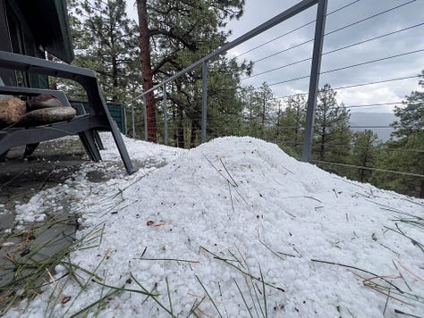
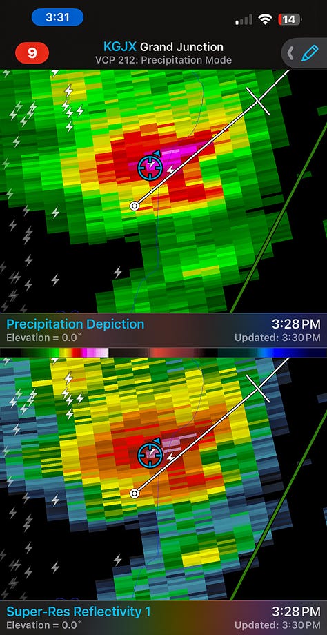


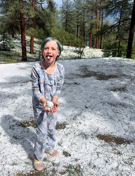
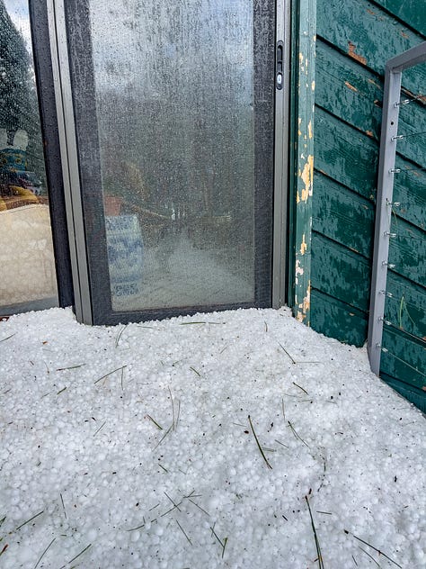
It’ll cost us thousands of dollars to repair the damage, but I feel fortunate it wasn’t worse, having lived through the epic May 8, 2017, hailstorm around Denver. The second most expensive hailstorm in U.S. history pummeled our place with nearly 2-inch stones that totaled our roof and led policyholders to file 167,000 auto and 100,600 homeowners insurance claims costing $2.3 billion.
The power of frozen water never ceases to amaze me! Or reach into my wallet. Fall’s approach also means payments are due for exorbitant but essential ski passes.
When the recent hailstorm hit, I was working on a piece about the cryosphere and how it’s defined (essentially, it’s the frozen portion of the Earth’s surface). Naturally, I wondered if you could technically include hail in this term.
After all, our whole neighborhood was covered with frozen H2O, and it was deep enough that some patches persisted until the next day. Maybe you’ve seen videos of snowplows being used to clear streets clogged with hailstones.
Hail’s typically fleeting nature on the ground is why it doesn’t get mentioned in the same breath as other elements of the cryosphere, such as snow cover, glaciers, permafrost, sea ice, ice sheets, ice shelves, icebergs, and river/lake ice. And hail isn’t exactly a big player when it comes to the water supply or the reflectivity of the Earth’s surface.
One of my defining features is an obsession with vocabulary and glossaries—the result of a youth misspent studying for the SAT—so I pulled together explanations of the cryosphere from textbooks and other reputable sources. Some of the simple definitions of the cryosphere would seem to allow hail’s inclusion:
“subsystem of the Earth characterized by the presence of snow, ice, and permafrost” — The Cryosphere and Global Environmental Change, by Olav Slaymaker and Richard Kelly.
“all forms of snow and ice, both terrestrial and marine” —The Global Cryosphere: Past, Present and Future, by Roger Barry and Thian Yew Gan.
A more detailed definition from the Cryosphere Glossary of the National Snow and Ice Data Center describes the cryosphere as “one of the earth's spheres of irregular form existing in the zone of interaction of the atmosphere, hydrosphere and lithosphere, distinguished by negative or zero temperature and the presence of water in the solid or super-cooled state.”
The Glossary of Meteorology from the American Meteorological Society defines the cryosphere as “that portion of the earth where natural materials (water, soil, etc.) occur in frozen form,” but it adds that it’s “generally limited to the polar latitudes and higher elevations.”
So I can’t say I have a strong case to elevate hail’s profile in cryospheric research, but I do know it’s a powerful—and expensive—form of frozen precipitation that demands our respect.

